
South Kaibab - Tonto - Bright Angel (Grand Canyon)
From Yaki Point, the route commits at once to the exposed descent of the South Kaibab Trail, a dramatic ridgeline path known for wide, open views and very little shade or water. It first reaches Ooh Aah Point, where the canyon opens suddenly in every direction, then continues through the sculpted upper formations to Cedar Ridge, before dropping farther along the narrowing ridge toward Skeleton Point, where the inner canyon and the Colorado River begin to come into view; from there, the trail descends toward The Tipoff, the important junction with the Tonto Trail on the broad mid-canyon platform.
Beyond The Tipoff, the hike continues down the South Kaibab Trail into the deeper, harsher world of the inner canyon, where pale upper cliffs give way to darker rock, dry slopes and the river corridor. The trail reaches the Kaibab Suspension Bridge, crosses the Colorado River, and briefly enters the Bright Angel area near the canyon floor; after this river-level detour, the route turns back the same way, climbs again toward The Tipoff, then leaves the South Kaibab line to follow the East Tonto Trail westward across the exposed Tonto Platform, a long natural balcony between the river depths and the South Rim walls.
The traverse then approaches Havasupai Gardens, an oasis-like place on the Bright Angel Trail and a culturally significant area associated with the Havasupai people, where cottonwoods, water and shade contrast sharply with the surrounding desert slopes. From there, the route begins its final ascent through the Bright Angel corridor, following shaded side-canyon walls, rest areas, long switchbacks and increasingly close views of the South Rim before emerging at Bright Angel Trailhead in Grand Canyon Village, completing a demanding journey from airy ridges to the Colorado River and back across the canyon’s layered terraces.
#Hiking #Canyon #Nature #Rock #River #Mountain #Park #Cliff
- Distance: 30.1 Km
- Elevation gain: 2,293 m
- Maximum elevation: 2,217 m
- Elevation loss: 2,426 m
- Minimum elevation: 749 m
- Moving time: 8 h 29 m
- Moving speed: 3.5 Km/h
- Maximum speed: 14.3 Km/h
- Total time: 1 d 1 h
- Global speed: 1.2 Km/h
Interactive trail map
Trail profile
- Distance: 30.1 Km
- Elevation gain: 2,293 m
- Maximum elevation: 2,217 m
- Elevation loss: 2,426 m
- Minimum elevation: 749 m
- Moving time: 8 h 29 m
- Moving speed: 3.5 Km/h
- Maximum speed: 14.3 Km/h
- Total time: 1 d 1 h
- Global speed: 1.2 Km/h
About this trail
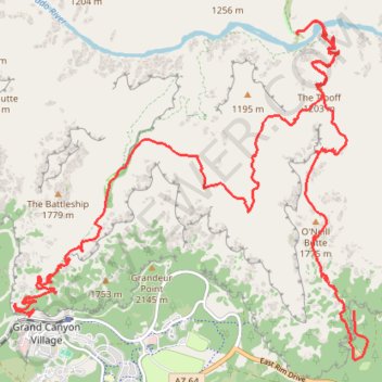
Name: South Kaibab - Tonto - Bright Angel (Grand Canyon) trail, distance, elevation, map, profile, GPS track
Start: Yaki Point Road, Coconino County, Arizona, United States (36.05786 -112.08322)
Coordinates: 36.05019 -112.14663 36.10156 -112.08067
Other hiking, mountain biking, running and outdoor activity trails
Click on a trail to view its statistics, map and profile.

Phantom Ranch via South Kaibab Trail, Skeleton Point, Bright Angel Trail and Indian Garden
United States > Arizona > Coconino County
From the South Kaibab Trailhead near Yaki Point, the route drops into the Grand Canyon on an open ridgeline, passing Ooh Aah Point, Cedar Ridge, Skeleton Point and The Tipoff, with broad views over the South Rim cliffs, the Tonto Platform and the deepening corridor of the Colorado River. It then descends…
Distance: 30.6 Km • Elevation gain: 2,650 m • Maximum elevation: 2,201 m

South Kaibab Trail to Phantom Ranch in Grand Canyon National Park
United States > Arizona > Coconino County
The South Kaibab Trail offers some of the most breathtaking views of the Grand Canyon, with expansive vistas that reveal the rugged terrain of the canyon’s depths. As you descend, you'll pass several key points like Ooh Aah Point, Cedar Ridge, Skeleton Point and O'Neill Butte, where the landscape opens up to…
Distance: 24.0 Km • Elevation gain: 1,944 m • Maximum elevation: 2,202 m

Grand Canyon Rim to River
United States > Arizona > Coconino County
From the South Kaibab Trailhead, this rim-to-river route immediately commits to one of the Grand Canyon’s most open and scenic descents, following a ridgeline where the canyon unfolds in wide layers of buttes, cliffs and side canyons. The trail passes Ooh Aah Point, Cedar Ridge, Skeleton Point and The Tipoff…
Distance: 27.3 Km • Elevation gain: 2,243 m • Maximum elevation: 2,201 m
Bright Angel Trail and South Kaibab Trail
United States > Arizona > Coconino County > Grand Canyon Village
From Grand Canyon Village, the route drops into the canyon on the Bright Angel Trail, following shaded switchbacks beneath layered cliffs before reaching the greener corridor of Havasupai Gardens and the drainage of Garden Creek. It then continues toward Pipe Creek Beach, where the landscape opens into the…
Distance: 25.3 Km • Elevation gain: 2,443 m • Maximum elevation: 2,202 m

Bright Angel Trail from South Rim to Bright Angel Campground in Grand Canyon National Park
United States > Arizona > Coconino County > Grand Canyon Village
The Bright Angel Trail offers a breathtaking journey through the Grand Canyon, descending from the South Rim to Bright Angel Campground. Hikers experience striking vistas of layered red rock, navigate shaded tunnels, and encounter rest areas like Havasupai Gardens and Indian Garden along the way. The final…
Distance: 16.2 Km • Elevation gain: 762 m • Maximum elevation: 2,087 m

3 Mile Resthouse (Grand Canyon)
United States > Arizona > Coconino County > Grand Canyon Village
From Grand Canyon Village, the route leaves the South Rim at the Bright Angel Trailhead near the historic rim area and drops onto the Bright Angel Trail, one of the park’s classic corridor trails, used through time by Indigenous peoples, miners, early tourists, hikers, and mule parties. The descent quickly…
Distance: 4.8 Km • Elevation gain: 262 m • Maximum elevation: 2,085 m

Pipe Creek Beach via Bright Angel Trail
United States > Arizona > Coconino County > Grand Canyon Village
From Grand Canyon Village on the South Rim, this route begins at the Bright Angel Trailhead and descends beneath the rim through a dramatic chain of switchbacks, with widening views across the canyon walls and the layered cliffs of the Bright Angel fault corridor. It passes the resthouse section of the upper…
Distance: 25.2 Km • Elevation gain: 2,225 m • Maximum elevation: 2,085 m

Grand Canyon Rim Trail from Mather Point to Bright Angel Trailhead
United States > Arizona > Coconino County
The Grand Canyon Rim Trail from Mather Point to the Bright Angel Trailhead offers hikers a leisurely walk along the South Rim, showcasing expansive vistas of the canyon's intricate rock formations and the meandering Colorado River below. Along the route, notable viewpoints such as Yavapai Point provide…
Distance: 10.1 Km • Elevation gain: 450 m • Maximum elevation: 2,180 m

Indian Garden (Grand Canyon)
United States > Arizona > Coconino County > Grand Canyon Village
From Grand Canyon Village on the South Rim, the route drops onto the Bright Angel Trail, passing the rim-side trailhead, the upper tunnel, Mallery’s Grotto pictographs, and the second tunnel as the path enters a shaded side canyon framed by high cliffs. The descent continues through long switchbacks and…
Distance: 7.5 Km • Elevation gain: 339 m • Maximum elevation: 2,085 m

1.5 Mile Resthouse (Grand Canyon)
United States > Arizona > Coconino County > Grand Canyon Village
From Grand Canyon Village, the route leaves the rim near Bright Angel Lodge and drops onto the Bright Angel Trail, quickly entering the shaded upper canyon through tight switchbacks and broad South Rim viewpoints. The path continues across pale cliffs, wooded pockets and exposed canyon slopes, following one of…
Distance: 2.6 Km • Elevation gain: 192 m • Maximum elevation: 2,085 m

Grand Canyon Rim to Rim Hike on South Kaibab Trail and North Kaibab Trail
United States > Arizona > Coconino County
From the South Kaibab Trailhead, this rim-to-rim hike drops from the South Rim into the open canyon on the South Kaibab Trail, passing Ooh Aah Point, Cedar Ridge, Skeleton Point and Tipoff Shelter before reaching the Kaibab Suspension Bridge, the Colorado River and the Bright Angel area near Phantom Ranch. The…
Distance: 33.5 Km • Elevation gain: 2,872 m • Maximum elevation: 2,517 m
Grand Canyon Rim to Rim Hike on North Kaibab Trail and Bright Angel Trail
United States > Arizona > Coconino County
Hike from North Kaibab Trailhead to Bright Angel Trailhead via Coconino Overlook, Cotonwood Campground, Bright Angel Creek, Phantom Ranch Village, Bright Angel Site, River Trail, Colorado River, Bright Angel Suspension Bridge, Pipe Creek, Garden Creek, Havasupai Gardens Campground and Mary Jane Coulter Lookout…
Distance: 37.6 Km • Elevation gain: 2,803 m • Maximum elevation: 2,517 m
3-Mile Resthouse via Bright Angel Trail in Grand Canyon National Park
United States > Arizona > Coconino County > Grand Canyon Village
Hiking the Bright Angel Trail to the 3-Mile Resthouse offers an intimate journey into the Grand Canyon's depths, showcasing the vastness of its ancient rock formations. As you descend, the towering canyon walls envelop you, revealing layers of geological history and offering glimpses of the winding Colorado…
Distance: 10.3 Km • Elevation gain: 1,141 m • Maximum elevation: 2,087 m

Ooh Aah Point via South Kaibab Trail
United States > Arizona > Coconino County
Starting at the South Kaibab Trailhead on the South Rim, the route leaves the rim through sparse high-desert woodland and quickly drops onto the South Kaibab Trail, following tight switchbacks below Yaki Point. The path then traverses exposed canyon slopes above the Pipe Creek drainage, with pale cliff bands,…
Distance: 3.2 Km • Elevation gain: 434 m • Maximum elevation: 2,202 m
Grand Canyon National Park Hike - Bright Angel Trail, Tonto Trail and South Kaibab Trail
United States > Arizona > Coconino County > Grand Canyon Village
Distance: 22.8 Km • Elevation gain: 1,682 m • Maximum elevation: 2,201 m


Ooh Aah Point via South Kaibab Trail in Grand Canyon National Park
United States > Arizona > Coconino County
The South Kaibab Trail to Ooh Aah Point is a delightful hike that rewards you with stunning views of the Grand Canyon right from the start. The descent is easygoing, allowing you to enjoy the dramatic landscapes, but don’t let the ease fool you—coming back up will definitely get your heart racing! Arriving…
Distance: 3.1 Km • Elevation gain: 375 m • Maximum elevation: 2,202 m


West Rim Trail
United States > Arizona > Coconino County > Grand Canyon Village
Hike on West Rim Trail to Hermit's Rest Point From Grand Canyon Village via Trailview Overlook, Maricopa Point, Powel Point, Hopi Point, Mohave Point, The Abyss and Pima Point in the Grand Canyon National Park. #Hiking #Canyon #Mountain #Nature #Park #Forest
Distance: 13.7 Km • Elevation gain: 771 m • Maximum elevation: 2,154 m

Bright Angel Trailhead via North Kaibab Trail and Bright Angel Trail
United States > Arizona > Coconino County > North Rim
Distance: 39.4 Km • Elevation gain: 3,122 m • Maximum elevation: 2,552 m