
Ooh Aah Point via South Kaibab Trail
Starting at the South Kaibab Trailhead on the South Rim, the route leaves the rim through sparse high-desert woodland and quickly drops onto the South Kaibab Trail, following tight switchbacks below Yaki Point.
The path then traverses exposed canyon slopes above the Pipe Creek drainage, with pale cliff bands, carved side ravines, and widening Grand Canyon views appearing in order along the descent.
Ooh Aah Point is the natural turnaround, where the trail suddenly opens onto a broad panorama before the route retraces the same South Kaibab Trail back to the trailhead.
#Hiking #Canyon #Forest #Nature #Desert #Rim #Views #Panorama
- Distance: 3.2 Km
- Elevation gain: 434 m
- Maximum elevation: 2,202 m
- Elevation loss: 434 m
- Minimum elevation: 1,947 m
Interactive trail map
Trail profile
- Distance: 3.2 Km
- Elevation gain: 434 m
- Maximum elevation: 2,202 m
- Elevation loss: 434 m
- Minimum elevation: 1,947 m
About this trail
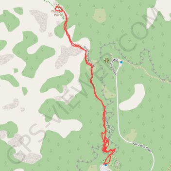
Name: Ooh Aah Point via South Kaibab Trail trail, distance, elevation, map, profile, GPS track
Start: South Kaibab trailhead access, Coconino County, Arizona, United States (36.05293 -112.08397)
End: South Kaibab trailhead access, Coconino County, Arizona, United States (36.05293 -112.08397)
Coordinates: 36.05293 -112.08718 36.06149 -112.08319
Other hiking, mountain biking, running and outdoor activity trails
Click on a trail to view its statistics, map and profile.

Phantom Ranch via South Kaibab Trail, Skeleton Point, Bright Angel Trail and Indian Garden
United States > Arizona > Coconino County
From the South Kaibab Trailhead near Yaki Point, the route drops into the Grand Canyon on an open ridgeline, passing Ooh Aah Point, Cedar Ridge, Skeleton Point and The Tipoff, with broad views over the South Rim cliffs, the Tonto Platform and the deepening corridor of the Colorado River. It then descends…
Distance: 30.6 Km • Elevation gain: 2,650 m • Maximum elevation: 2,201 m

South Kaibab - Tonto - Bright Angel (Grand Canyon)
United States > Arizona > Coconino County
From Yaki Point, the route commits at once to the exposed descent of the South Kaibab Trail, a dramatic ridgeline path known for wide, open views and very little shade or water. It first reaches Ooh Aah Point, where the canyon opens suddenly in every direction, then continues through the sculpted upper…
Distance: 30.1 Km • Elevation gain: 2,293 m • Maximum elevation: 2,217 m

South Kaibab Trail to Phantom Ranch in Grand Canyon National Park
United States > Arizona > Coconino County
The South Kaibab Trail offers some of the most breathtaking views of the Grand Canyon, with expansive vistas that reveal the rugged terrain of the canyon’s depths. As you descend, you'll pass several key points like Ooh Aah Point, Cedar Ridge, Skeleton Point and O'Neill Butte, where the landscape opens up to…
Distance: 24.0 Km • Elevation gain: 1,944 m • Maximum elevation: 2,202 m

Grand Canyon Rim to River
United States > Arizona > Coconino County
From the South Kaibab Trailhead, this rim-to-river route immediately commits to one of the Grand Canyon’s most open and scenic descents, following a ridgeline where the canyon unfolds in wide layers of buttes, cliffs and side canyons. The trail passes Ooh Aah Point, Cedar Ridge, Skeleton Point and The Tipoff…
Distance: 27.3 Km • Elevation gain: 2,243 m • Maximum elevation: 2,201 m
Bright Angel Trail and South Kaibab Trail
United States > Arizona > Coconino County > Grand Canyon Village
From Grand Canyon Village, the route drops into the canyon on the Bright Angel Trail, following shaded switchbacks beneath layered cliffs before reaching the greener corridor of Havasupai Gardens and the drainage of Garden Creek. It then continues toward Pipe Creek Beach, where the landscape opens into the…
Distance: 25.3 Km • Elevation gain: 2,443 m • Maximum elevation: 2,202 m

Grand Canyon Rim to Rim Hike on South Kaibab Trail and North Kaibab Trail
United States > Arizona > Coconino County
From the South Kaibab Trailhead, this rim-to-rim hike drops from the South Rim into the open canyon on the South Kaibab Trail, passing Ooh Aah Point, Cedar Ridge, Skeleton Point and Tipoff Shelter before reaching the Kaibab Suspension Bridge, the Colorado River and the Bright Angel area near Phantom Ranch. The…
Distance: 33.5 Km • Elevation gain: 2,872 m • Maximum elevation: 2,517 m
Grand Canyon Rim to Rim Hike on North Kaibab Trail and Bright Angel Trail
United States > Arizona > Coconino County
Hike from North Kaibab Trailhead to Bright Angel Trailhead via Coconino Overlook, Cotonwood Campground, Bright Angel Creek, Phantom Ranch Village, Bright Angel Site, River Trail, Colorado River, Bright Angel Suspension Bridge, Pipe Creek, Garden Creek, Havasupai Gardens Campground and Mary Jane Coulter Lookout…
Distance: 37.6 Km • Elevation gain: 2,803 m • Maximum elevation: 2,517 m
Grand Canyon National Park Hike - Bright Angel Trail, Tonto Trail and South Kaibab Trail
United States > Arizona > Coconino County > Grand Canyon Village
Distance: 22.8 Km • Elevation gain: 1,682 m • Maximum elevation: 2,201 m


Ooh Aah Point via South Kaibab Trail in Grand Canyon National Park
United States > Arizona > Coconino County
The South Kaibab Trail to Ooh Aah Point is a delightful hike that rewards you with stunning views of the Grand Canyon right from the start. The descent is easygoing, allowing you to enjoy the dramatic landscapes, but don’t let the ease fool you—coming back up will definitely get your heart racing! Arriving…
Distance: 3.1 Km • Elevation gain: 375 m • Maximum elevation: 2,202 m


Bright Angel Trailhead via North Kaibab Trail and Bright Angel Trail
United States > Arizona > Coconino County > North Rim
Distance: 39.4 Km • Elevation gain: 3,122 m • Maximum elevation: 2,552 m