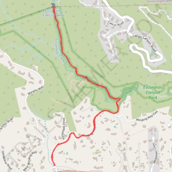
Escondido Falls Trail in Escondido Canyon Park
The Escondido Falls Trail in Malibu offers hikers a journey through diverse landscapes, beginning with a paved path flanked by impressive hillside residences and ocean vistas. As the trail progresses into Escondido Canyon Park, adventurers are enveloped by a canopy of oak and sycamore trees, with the soothing sounds of Escondido Creek accompanying them. The highlight is the serene Lower Escondido Falls, a picturesque waterfall cascading over fern-covered rocks, providing a refreshing and tranquil retreat. #Hiking #Waterfall #Forest #Nature
- Distance: 5.8 Km
- Elevation gain: 164 m
- Maximum elevation: 128 m
- Elevation loss: 164 m
- Minimum elevation: 44 m
- Moving time: 1 h 32 m
- Moving speed: 3.7 Km/h
- Maximum speed: 6.6 Km/h
- Total time: 2 h 4 m
- Global speed: 2.8 Km/h
Interactive trail map
Trail profile
- Distance: 5.8 Km
- Elevation gain: 164 m
- Maximum elevation: 128 m
- Elevation loss: 164 m
- Minimum elevation: 44 m
- Moving time: 1 h 32 m
- Moving speed: 3.7 Km/h
- Maximum speed: 6.6 Km/h
- Total time: 2 h 4 m
- Global speed: 2.8 Km/h
About this trail
Name: Escondido Falls Trail in Escondido Canyon Park trail, distance, elevation, map, profile, GPS track
Start: Winding Way East, Malibu, Los Angeles County, California, 90265, United States (34.02660 -118.77992)
Coordinates: 34.02660 -118.78029 34.04224 -118.77217
Other hiking, mountain biking, running and outdoor activity trails
Click on a trail to view its statistics, map and profile.