
Yearling Trail
From the trailhead near Silver Glen Springs, the Yearling Trail heads into the Big Scrub of Ocala National Forest, crossing open sand pine scrub before reaching the longleaf pine and turkey oak landscape of Pat’s Island, once home to the Long family settlement.
The route passes the old frontier traces of Pat’s Island, including sinkholes, a cattle dip, homestead remains, and Long Cemetery, where the human history behind The Yearling is closely tied to the surrounding forest.
The loop also follows the Florida Trail through the Juniper Prairie Wilderness, returning across scrubby ridges, pine flatwoods, oak scrub, prairie edges, shallow wetlands, and quiet sandy forest paths before completing the route back at the starting area.
#Hiking #Loop #Forest #Nature #Wilderness
- Distance: 13.9 Km
- Elevation gain: 73 m
- Maximum elevation: 28 m
- Elevation loss: 73 m
- Minimum elevation: 7 m
- Moving time: 4 h 15 m
- Moving speed: 3.3 Km/h
- Maximum speed: 38.7 Km/h
- Total time: 5 h 31 m
- Global speed: 2.5 Km/h
Interactive trail map
Trail profile
- Distance: 13.9 Km
- Elevation gain: 73 m
- Maximum elevation: 28 m
- Elevation loss: 73 m
- Minimum elevation: 7 m
- Moving time: 4 h 15 m
- Moving speed: 3.3 Km/h
- Maximum speed: 38.7 Km/h
- Total time: 5 h 31 m
- Global speed: 2.5 Km/h
About this trail
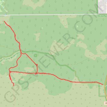
Name: Yearling Trail trail, distance, elevation, map, profile, GPS track
Start: FL 19, Yellow Bluff, Salt Springs, Marion County, Florida, United States (29.24515 -81.64860)
End: FL 19, Yellow Bluff, Salt Springs, Marion County, Florida, United States (29.24517 -81.64862)
Coordinates: 29.24467 -81.68844 29.26738 -81.64860