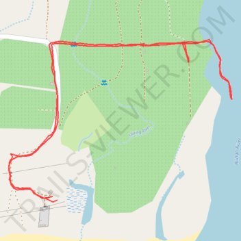
Walk to Bungo River
- Distance: 2.5 Km
- Elevation gain: 10 m
- Maximum elevation: 16 m
- Elevation loss: 9 m
- Minimum elevation: 7 m
- Moving time: 50 m 34 s
- Moving speed: 3.0 Km/h
- Maximum speed: 5.8 Km/h
- Total time: 1 h 9 m
- Global speed: 2.2 Km/h
Interactive trail map
Trail profile
About this trail
Name: Walk to Bungo River trail, distance, elevation, map, profile, GPS track
Start: Mapalad, Aurora, Central Luzon, Philippines (16.12620 121.92266)
End: Mapalad, Aurora, Central Luzon, Philippines (16.12629 121.92254)
Coordinates: 16.12616 121.92145 16.13008 121.92704