Thank you for supporting this site ❤️
Make a donation
Make a donation
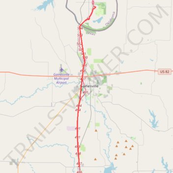
Tracked with OSMTracker for Android™
I-35 NB
- Distance: 33.1 Km
- Elevation gain: 201 m
- Maximum elevation: 252 m
- Elevation loss: 182 m
- Minimum elevation: 209 m
Interactive trail map
Thank you for supporting this site ❤️
Make a donation
Make a donation
Trail profile
- Distance: 33.1 Km
- Elevation gain: 201 m
- Maximum elevation: 252 m
- Elevation loss: 182 m
- Minimum elevation: 209 m
Thank you for supporting this site ❤️
Make a donation
Make a donation
About this trail
Name: Tracked with OSMTracker for Android™ trail, distance, elevation, map, profile, GPS track
Coordinates: 33.48798 -97.16596 33.75892 -97.12882
Thank you for supporting this site ❤️
Make a donation
Make a donation
Other hiking, mountain biking, running and outdoor activity trails
Click on a trail to view its statistics, map and profile.
Tracked with OSMTracker for Android™
United States > Oklahoma > Love County > Thackerville
I-35 SB
Distance: 33.3 Km • Elevation gain: 182 m • Maximum elevation: 240 m