Thank you for supporting this site ❤️
Make a donation
Make a donation
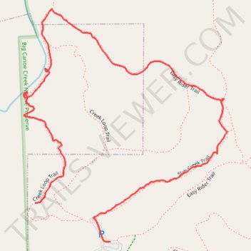
Big Canoe Creek Nature Preserve
- Distance: 2.7 Km
- Elevation gain: 67 m
- Maximum elevation: 269 m
- Elevation loss: 73 m
- Minimum elevation: 208 m
- Moving time: 46 m 8 s
- Moving speed: 3.5 Km/h
- Maximum speed: 6.2 Km/h
- Total time: 54 m 52 s
- Global speed: 2.9 Km/h
Interactive trail map
Thank you for supporting this site ❤️
Make a donation
Make a donation
Trail profile
- Distance: 2.7 Km
- Elevation gain: 67 m
- Maximum elevation: 269 m
- Elevation loss: 73 m
- Minimum elevation: 208 m
- Moving time: 46 m 8 s
- Moving speed: 3.5 Km/h
- Maximum speed: 6.2 Km/h
- Total time: 54 m 52 s
- Global speed: 2.9 Km/h
Thank you for supporting this site ❤️
Make a donation
Make a donation
About this trail
Name: Big Canoe Creek Nature Preserve trail, distance, elevation, map, profile, GPS track
Start: Creek Loop Trail, Springville, St. Clair County, Alabama, 35146, United States (33.79657 -86.48511)
End: Slab Creek Trail, Springville, St. Clair County, Alabama, 35146, United States (33.79536 -86.48227)
Coordinates: 33.79536 -86.48554 33.80264 -86.47785
Thank you for supporting this site ❤️
Make a donation
Make a donation
Other hiking, mountain biking, running and outdoor activity trails
Click on a trail to view its statistics, map and profile.
Big Canoe Creek Nature Preserve Loop Trail
United States > Alabama > St. Clair County > Springville
Distance: 7.5 Km • Elevation gain: 208 m • Maximum elevation: 303 m
Big Canoe Creek Nature Preserve Loop Walk
United States > Alabama > St. Clair County > Springville
Distance: 4.3 Km • Elevation gain: 78 m • Maximum elevation: 269 m