Thank you for supporting this site ❤️
Make a donation
Make a donation
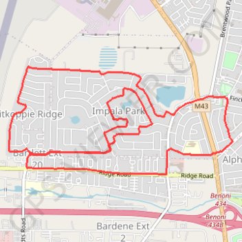
Bicycle
- Distance: 13.4 Km
- Elevation gain: 68 m
- Maximum elevation: 1,685 m
- Elevation loss: 68 m
- Minimum elevation: 1,648 m
- Moving time: 57 m 28 s
- Moving speed: 14.0 Km/h
- Maximum speed: 22.0 Km/h
- Total time: 1 h 2 m
- Global speed: 12.9 Km/h
Interactive trail map
Thank you for supporting this site ❤️
Make a donation
Make a donation
Trail profile
- Distance: 13.4 Km
- Elevation gain: 68 m
- Maximum elevation: 1,685 m
- Elevation loss: 68 m
- Minimum elevation: 1,648 m
- Moving time: 57 m 28 s
- Moving speed: 14.0 Km/h
- Maximum speed: 22.0 Km/h
- Total time: 1 h 2 m
- Global speed: 12.9 Km/h
Thank you for supporting this site ❤️
Make a donation
Make a donation
About this trail
Name: Bicycle trail, distance, elevation, map, profile, GPS track
Coordinates: -26.16845 28.25273 -26.15615 28.28130
Thank you for supporting this site ❤️
Make a donation
Make a donation