Make a donation
Annies Canyon Loop
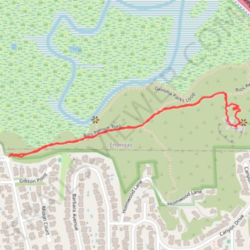
Via Rios Avenue Trail in San Elijo Lagoon Ecological Reserve #Hiking #Loop #Canyon #Forest #River
- Distance: 2.1 Km
- Elevation gain: 58 m
- Maximum elevation: 49 m
- Elevation loss: 58 m
- Minimum elevation: 5 m
- Moving time: 28 m 38 s
- Moving speed: 4.4 Km/h
- Maximum speed: 6.4 Km/h
- Total time: 29 m 56 s
- Global speed: 4.2 Km/h
Interactive trail map
Make a donation
Trail profile
- Distance: 2.1 Km
- Elevation gain: 58 m
- Maximum elevation: 49 m
- Elevation loss: 58 m
- Minimum elevation: 5 m
- Moving time: 28 m 38 s
- Moving speed: 4.4 Km/h
- Maximum speed: 6.4 Km/h
- Total time: 29 m 56 s
- Global speed: 4.2 Km/h
Make a donation
About this trail
Name: Annies Canyon Loop trail, distance, elevation, map, profile, GPS track
Coordinates: 33.00367 -117.27241 33.00578 -117.26335
Make a donation
Other hiking, mountain biking, running and outdoor activity trails
Click on a trail to view its statistics, map and profile.
Annie's Canyon Trail via Solana Hills Trail, Rios Avenue Trail and Gemma Parks Loop
United States > California > San Diego County > Solana Beach
The hike along Solana Hills Trail, Rios Avenue Trail, and Gemma Parks Loop to Annie’s Canyon in the San Elijo Lagoon Ecological Reserve offers a serene blend of coastal wetlands, native chaparral, and sculpted sandstone canyons. As you meander through the trails, you'll encounter sweeping views of the…
Distance: 3.9 Km • Elevation gain: 130 m • Maximum elevation: 77 m
Annies Canyon Trail and Gemma Parks Loop in San Elijo Lagoon Ecological Reserve
United States > California > San Diego County > Solana Beach
Embarking from the Rios Trailhead, the combined Annie's Canyon Trail and Gemma Parks Loop offers hikers an immersive journey through the diverse landscapes of the San Elijo Lagoon Ecological Reserve. The route showcases vibrant wetlands teeming with birdlife, leading to the captivating sandstone slot canyon of…
Distance: 2.5 Km • Elevation gain: 67 m • Maximum elevation: 49 m