Wave Cave Trail
Interactive trail map
Trail profile
About this trail
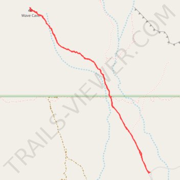
Name: Wave Cave Trail trail, distance, elevation, map, profile, GPS track
End: Carney Springs Trail, Pinal County, Arizona, United States (33.38588 -111.36320)
Coordinates: 33.38588 -111.37714 33.40219 -111.36304
Other hiking, mountain biking, running and outdoor activity trails
Click on a trail to view its statistics, map and profile.
Wave Cave Trail in Superstition Wilderness
United States > Arizona > Pinal County
The Wave Cave Trail in Arizona's Superstition Mountains offers hikers a journey through a landscape adorned with towering saguaro cacti, prickly pear, and mesquite trees. The trail leads to a captivating cave featuring a distinctive rock formation resembling a wave, providing a unique photo opportunity. From…
Distance: 4.9 Km • Elevation gain: 292 m • Maximum elevation: 965 m
Fremont Saddle via Peralta Canyon Trail in Superstition Wilderness
United States > Arizona > Pinal County
The Peralta Trail to Fremont Saddle offers a rewarding hike through Arizona's Superstition Mountains, culminating in a panoramic view of the iconic Weavers Needle. As you ascend, the trail winds through diverse desert flora, including oak and mesquite trees, with rugged volcanic rock formations towering above.…
Distance: 7.3 Km • Elevation gain: 413 m • Maximum elevation: 1,150 m
Fremont Saddle and Weaver's Needle Loop via Peralta Canyon Trail and Cave Trail
United States > Arizona > Pinal County
This loop offers an excellent combination of rugged desert beauty and rewarding vistas. As you ascend the Peralta Canyon Trail, the trail weaves through a vibrant Sonoran Desert landscape, featuring towering saguaro cacti and jagged rock pinnacles. Once reaching Fremont Saddle, hikers are treated to a…
Distance: 8.6 Km • Elevation gain: 499 m • Maximum elevation: 1,162 m