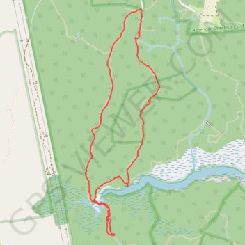
Parkers Creek loop trail
- Distance: 5.4 Km
- Elevation gain: 84 m
- Maximum elevation: 46 m
- Elevation loss: 84 m
- Minimum elevation: 1 m
- Moving time: 1 h 35 m
- Moving speed: 3.4 Km/h
- Maximum speed: 12.5 Km/h
- Total time: 1 h 55 m
- Global speed: 2.8 Km/h
Interactive trail map
Trail profile
- Distance: 5.4 Km
- Elevation gain: 84 m
- Maximum elevation: 46 m
- Elevation loss: 84 m
- Minimum elevation: 1 m
- Moving time: 1 h 35 m
- Moving speed: 3.4 Km/h
- Maximum speed: 12.5 Km/h
- Total time: 1 h 55 m
- Global speed: 2.8 Km/h
About this trail
Name: Parkers Creek loop trail trail, distance, elevation, map, profile, GPS track
Coordinates: 38.53003 -76.54343 38.54714 -76.53627
Other hiking, mountain biking, running and outdoor activity trails
Click on a trail to view its statistics, map and profile.
Prince Frederick Trail
United States > Maryland > Calvert County > Prince Frederick > Hidden Valley
Distance: 6.2 Km • Elevation gain: 112 m • Maximum elevation: 45 m