Thank you for supporting this site ❤️
Make a donation
Make a donation
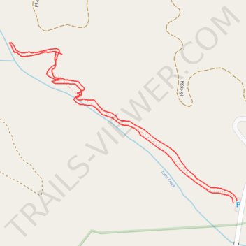
Toms Creek Falls Trail
- Distance: 1.7 Km
- Elevation gain: 79 m
- Maximum elevation: 587 m
- Elevation loss: 78 m
- Minimum elevation: 508 m
- Moving time: 30 m 32 s
- Moving speed: 3.3 Km/h
- Maximum speed: 6.9 Km/h
- Total time: 34 m 2 s
- Global speed: 3.0 Km/h
Interactive trail map
Thank you for supporting this site ❤️
Make a donation
Make a donation
Trail profile
- Distance: 1.7 Km
- Elevation gain: 79 m
- Maximum elevation: 587 m
- Elevation loss: 78 m
- Minimum elevation: 508 m
- Moving time: 30 m 32 s
- Moving speed: 3.3 Km/h
- Maximum speed: 6.9 Km/h
- Total time: 34 m 2 s
- Global speed: 3.0 Km/h
Thank you for supporting this site ❤️
Make a donation
Make a donation
About this trail
Name: Toms Creek Falls Trail trail, distance, elevation, map, profile, GPS track
Coordinates: 35.77465 -82.06277 35.77805 -82.05681
Thank you for supporting this site ❤️
Make a donation
Make a donation