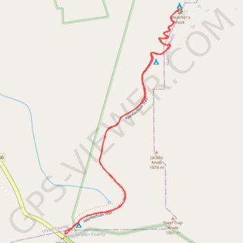
Preacher's Rock from Woody Gap via Appalachian Trail in Blood Mountain Wilderness
The hike to Preacher's Rock is a moderately challenging trek that offers an impressive payoff with its expansive views. Along the route, hikers will encounter rocky terrain, root-laden paths, and sharp switchbacks as they ascend towards the summit of Big Cedar Mountain. At Preacher's Rock, the view stretches across a vast valley with Mount Yonah and Cowrock Mountain in the distance, making it an ideal spot for a rest or picnic. #Hiking #Mountain #Overlook #Rock #Forest #Nature
- Distance: 3.2 Km
- Elevation gain: 136 m
- Maximum elevation: 1,074 m
- Elevation loss: 136 m
- Minimum elevation: 966 m
- Moving time: 47 m 7 s
- Moving speed: 4.1 Km/h
- Maximum speed: 8.5 Km/h
- Total time: 53 m 38 s
- Global speed: 3.6 Km/h
Interactive trail map
Trail profile
- Distance: 3.2 Km
- Elevation gain: 136 m
- Maximum elevation: 1,074 m
- Elevation loss: 136 m
- Minimum elevation: 966 m
- Moving time: 47 m 7 s
- Moving speed: 4.1 Km/h
- Maximum speed: 8.5 Km/h
- Total time: 53 m 38 s
- Global speed: 3.6 Km/h
About this trail
Name: Preacher's Rock from Woody Gap via Appalachian Trail in Blood Mountain Wilderness trail, distance, elevation, map, profile, GPS track
Start: Appalachian Trail, Lumpkin County, Georgia, United States (34.67775 -83.99984)
End: Appalachian Trail, Lumpkin County, Georgia, United States (34.67778 -83.99991)
Coordinates: 34.67774 -83.99991 34.68723 -83.99406