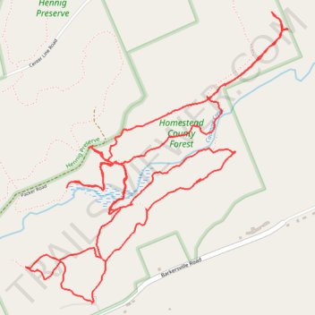
Homestead County Forest Trails
- Distance: 10.2 Km
- Elevation gain: 168 m
- Maximum elevation: 458 m
- Elevation loss: 167 m
- Minimum elevation: 404 m
- Moving time: 2 h 11 m
- Moving speed: 4.7 Km/h
- Maximum speed: 11.3 Km/h
- Total time: 2 h 33 m
- Global speed: 4.0 Km/h
Interactive trail map
Trail profile
- Distance: 10.2 Km
- Elevation gain: 168 m
- Maximum elevation: 458 m
- Elevation loss: 167 m
- Minimum elevation: 404 m
- Moving time: 2 h 11 m
- Moving speed: 4.7 Km/h
- Maximum speed: 11.3 Km/h
- Total time: 2 h 33 m
- Global speed: 4.0 Km/h
About this trail
Name: Homestead County Forest Trails trail, distance, elevation, map, profile, GPS track
Start: Tower Road, Town of Providence, Saratoga County, New York, United States (43.09957 -74.03265)
Coordinates: 43.09957 -74.03747 43.11497 -74.01833
Other hiking, mountain biking, running and outdoor activity trails
Click on a trail to view its statistics, map and profile.
Henning Preserve Loop Trail
United States > New York > Saratoga County > Hagedorns Mills
Distance: 8.7 Km • Elevation gain: 110 m • Maximum elevation: 497 m