Thank you for supporting this site ❤️
Make a donation
Make a donation
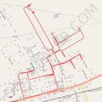
Tolar Walking
- Distance: 6.7 Km
- Elevation gain: 23 m
- Maximum elevation: 327 m
- Elevation loss: 23 m
- Minimum elevation: 311 m
- Moving time: 1 h 34 m
- Moving speed: 4.3 Km/h
- Maximum speed: 5.5 Km/h
- Total time: 1 h 39 m
- Global speed: 4.1 Km/h
Interactive trail map
Thank you for supporting this site ❤️
Make a donation
Make a donation
Trail profile
- Distance: 6.7 Km
- Elevation gain: 23 m
- Maximum elevation: 327 m
- Elevation loss: 23 m
- Minimum elevation: 311 m
- Moving time: 1 h 34 m
- Moving speed: 4.3 Km/h
- Maximum speed: 5.5 Km/h
- Total time: 1 h 39 m
- Global speed: 4.1 Km/h
Thank you for supporting this site ❤️
Make a donation
Make a donation
About this trail
Name: Tolar Walking trail, distance, elevation, map, profile, GPS track
Coordinates: 32.38855 -97.92395 32.39903 -97.91530
Thank you for supporting this site ❤️
Make a donation
Make a donation