Make a donation
Point Lobos Loop
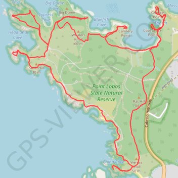
Interactive trail map
Make a donation
Trail profile
- Distance: 10.7 Km
- Elevation gain: 248 m
- Maximum elevation: 63 m
- Elevation loss: 248 m
- Minimum elevation: -1 m
Make a donation
About this trail
Name: Point Lobos Loop trail, distance, elevation, map, profile, GPS track
Start: Carmelo Meadow Trail, Monterey County, California, 93922, United States (36.51602 -121.93846)
End: Carmelo Meadow Trail, Monterey County, California, 93922, United States (36.51602 -121.93846)
Coordinates: 36.50725 -121.95387 36.52290 -121.93576
Make a donation
Other hiking, mountain biking, running and outdoor activity trails
Click on a trail to view its statistics, map and profile.
Point Lobos Loop
United States > California > Monterey County
Point Lobos Natural Reserve offers an amazing blend of coastal beauty and wildlife, making it a perfect escape into nature. From serene coves to rocky shores, trails are well-maintained and easy to follow, with plenty of chances to spot sea otters, birds, and sea lions along the way. With sweeping Pacific…
Distance: 10.3 Km • Elevation gain: 206 m • Maximum elevation: 33 m