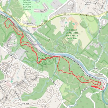
Patapsco Valley State Park Ilchester Area Loop
- Distance: 9.0 Km
- Elevation gain: 315 m
- Maximum elevation: 109 m
- Elevation loss: 315 m
- Minimum elevation: 34 m
- Moving time: 2 h 10 m
- Moving speed: 4.1 Km/h
- Maximum speed: 10.0 Km/h
- Total time: 2 h 27 m
- Global speed: 3.7 Km/h
Interactive trail map
Trail profile
- Distance: 9.0 Km
- Elevation gain: 315 m
- Maximum elevation: 109 m
- Elevation loss: 315 m
- Minimum elevation: 34 m
- Moving time: 2 h 10 m
- Moving speed: 4.1 Km/h
- Maximum speed: 10.0 Km/h
- Total time: 2 h 27 m
- Global speed: 3.7 Km/h
About this trail
Name: Patapsco Valley State Park Ilchester Area Loop trail, distance, elevation, map, profile, GPS track
Start: 53, Ilchester Road, Ilchester, Howard County, Maryland, 21043, United States (39.25006 -76.76470)
End: 53, Ilchester Road, Ilchester, Howard County, Maryland, 21043, United States (39.25008 -76.76471)
Coordinates: 39.24936 -76.79147 39.26412 -76.76470
Other hiking, mountain biking, running and outdoor activity trails
Click on a trail to view its statistics, map and profile.
St. Mary’s College and Chapel Ruins Loop in Patapsco Valley State Park Ilchester Area
United States > Maryland > Howard County > Ilchester
The St. Mary’s College and Chapel Ruins Loop offers hikers a unique blend of nature and history, showcasing the remnants of a once-grand seminary that dates back to the late 19th century. As you walk along the trail, you’ll encounter intriguing ruins, including stone remnants and a striking metal cross,…
Distance: 3.3 Km • Elevation gain: 82 m • Maximum elevation: 116 m
Hike through Patapsco Valley State Park Ilchester Area
United States > Maryland > Howard County > Ilchester
Distance: 8.5 Km • Elevation gain: 279 m • Maximum elevation: 108 m
Patapsco Valley State Park - Hilton Area Loop Hike
United States > Maryland > Baltimore County > Catonsville
Distance: 6.5 Km • Elevation gain: 182 m • Maximum elevation: 122 m
St. Marys's College Ruins and Patapsco Valley State Park Illchester Area hike
United States > Maryland > Howard County > Ilchester
Distance: 4.8 Km • Elevation gain: 152 m • Maximum elevation: 104 m
Crossing Patapsco Valley State Park Ilchester Area
United States > Maryland > Howard County > Ilchester
Morning Hike
Distance: 5.8 Km • Elevation gain: 225 m • Maximum elevation: 110 m
Patapsco Valley State Park - Horse Farm Area
United States > Maryland > Howard County > Ellicott City
Distance: 13.0 Km • Elevation gain: 240 m • Maximum elevation: 113 m
Patapsco Valley State Park Hilton Area Loop
United States > Maryland > Baltimore County > Catonsville
Distance: 9.9 Km • Elevation gain: 251 m • Maximum elevation: 125 m
Patapsco River and Santee Branch Trail loop
United States > Maryland > Baltimore County > Catonsville
Distance: 9.0 Km • Elevation gain: 221 m • Maximum elevation: 123 m
Patapsco Valley State Park Ilchester Area
United States > Maryland > Howard County > Ilchester
Morning Hike
Distance: 7.7 Km • Elevation gain: 261 m • Maximum elevation: 109 m
Patapsco Valley State Park Ilchester Area
United States > Maryland > Howard County > Ilchester
Morning Hike
Distance: 7.2 Km • Elevation gain: 215 m • Maximum elevation: 108 m
Patapsco Valley State Park Hilton Area Loop
United States > Maryland > Howard County > Ilchester
Distance: 9.9 Km • Elevation gain: 273 m • Maximum elevation: 123 m
Patapsco Valley State Park Hilton Area
United States > Maryland > Baltimore County > Catonsville
Morning Loop Hike
Distance: 10.9 Km • Elevation gain: 234 m • Maximum elevation: 125 m
Old Ilchester Quarry Scouting
United States > Maryland > Howard County > Ilchester
Patapsco Valley State Park - Morning Hike
Distance: 8.3 Km • Elevation gain: 292 m • Maximum elevation: 108 m
Patapsco Valley State Park Hilton Area
United States > Maryland > Baltimore County > Catonsville
Distance: 8.9 Km • Elevation gain: 240 m • Maximum elevation: 123 m
Scouting Old Ilchester
United States > Maryland > Howard County > Ilchester
Morning Hike
Distance: 7.9 Km • Elevation gain: 255 m • Maximum elevation: 108 m
Patapsco Valley State Park
United States > Maryland > Baltimore County > Catonsville
Morning Loop Hike
Distance: 9.9 Km • Elevation gain: 320 m • Maximum elevation: 125 m
Scouting Old Ilchester
United States > Maryland > Howard County > Ilchester
Morning Hike
Distance: 7.9 Km • Elevation gain: 224 m • Maximum elevation: 108 m
Morning Hike
United States > Maryland > Baltimore County > Catonsville
Distance: 9.6 Km • Elevation gain: 223 m • Maximum elevation: 123 m
Patapsco Valley State Park - Ellicott City
United States > Maryland > Howard County > Ellicott City
Distance: 12.6 Km • Elevation gain: 256 m • Maximum elevation: 148 m