Moel-Y-Gest Loop Trail
- Distance: 6.6 Km
- Elevation gain: 294 m
- Maximum elevation: 248 m
- Elevation loss: 295 m
- Minimum elevation: 0 m
- Moving time: 1 h 56 m
- Moving speed: 3.4 Km/h
- Maximum speed: 7.5 Km/h
- Total time: 2 h 20 m
- Global speed: 2.8 Km/h
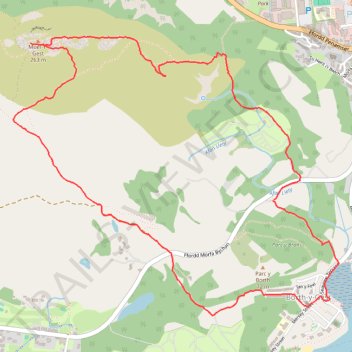
Interactive trail map
Trail profile
- Distance: 6.6 Km
- Elevation gain: 294 m
- Maximum elevation: 248 m
- Elevation loss: 295 m
- Minimum elevation: 0 m
- Moving time: 1 h 56 m
- Moving speed: 3.4 Km/h
- Maximum speed: 7.5 Km/h
- Total time: 2 h 20 m
- Global speed: 2.8 Km/h
About this trail
Name: Moel-Y-Gest Loop Trail trail, distance, elevation, map, profile, GPS track
Start: Ffordd Morfa Bychan, Porthmadog, Gwynedd, Wales, LL49 9UT, United Kingdom (52.92030 -4.14054)
End: Ffordd Morfa Bychan, Porthmadog, Gwynedd, Wales, LL49 9UT, United Kingdom (52.92035 -4.14042)
Coordinates: 52.91481 -4.16110 52.92815 -4.13528
Other hiking, mountain biking, running and outdoor activity trails
Click on a trail to view its statistics, map and profile.
Walk along the coast and beach between Borth-y-Gêst and Morfa Bychan
United Kingdom > Wales > Gwynedd > Borth-y-Gêst
Distance: 4.2 Km • Elevation gain: 68 m • Maximum elevation: 32 m
Borth-y-Gest Loop Walk
United Kingdom > Wales > Gwynedd > Porthmadog
Distance: 6.3 Km • Elevation gain: 127 m • Maximum elevation: 34 m
Porthmadog loop
United Kingdom > Wales > Gwynedd > Porthmadog
Distance: 13.4 Km • Elevation gain: 212 m • Maximum elevation: 79 m