Lots of waterfalls!
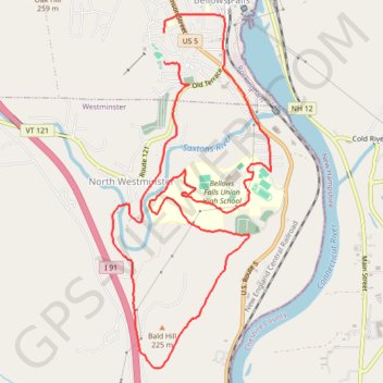
- Distance: 11.4 Km
- Elevation gain: 219 m
- Maximum elevation: 160 m
- Elevation loss: 228 m
- Minimum elevation: 83 m
- Moving time: 59 m 45 s
- Moving speed: 11.5 Km/h
- Maximum speed: 19.5 Km/h
- Total time: 1 h 10 m
- Global speed: 9.7 Km/h
Interactive trail map
Trail profile
- Distance: 11.4 Km
- Elevation gain: 219 m
- Maximum elevation: 160 m
- Elevation loss: 228 m
- Minimum elevation: 83 m
- Moving time: 59 m 45 s
- Moving speed: 11.5 Km/h
- Maximum speed: 19.5 Km/h
- Total time: 1 h 10 m
- Global speed: 9.7 Km/h
About this trail
Name: Lots of waterfalls! trail, distance, elevation, map, profile, GPS track
Coordinates: 43.10270 -72.45735 43.13281 -72.43883
Other hiking, mountain biking, running and outdoor activity trails
Click on a trail to view its statistics, map and profile.