
San Juan Hot Springs
From Ortega Flats Campground in Ronald W. Caspers Wilderness Park, the hike leaves the camping area and enters the San Juan Creek corridor, following a quiet canyon setting shaped by seasonal water, riparian vegetation, oak woodland, and chaparral-covered slopes.
The route continues upstream along San Juan Creek Trail, gradually approaching Ortega Highway while alternating between shaded creekside passages, open foothill views, and rugged folds of the Santa Ana foothills.
Near the end, the path reaches the historic San Juan Hot Springs area by Hot Spring Canyon, where the former geothermal resort site and its fenced springs mark a distinctive landmark at the edge of the park’s wilderness landscape.
#Hiking #Mountain #Nature #Forest #Wilderness #Park #Canyon #Creek #Springs
- Distance: 16.4 Km
- Elevation gain: 380 m
- Maximum elevation: 248 m
- Elevation loss: 380 m
- Minimum elevation: 125 m
- Moving time: 2 h 58 m
- Moving speed: 5.5 Km/h
- Maximum speed: 40.6 Km/h
- Total time: 2 h 58 m
- Global speed: 5.5 Km/h
Interactive trail map
Trail profile
- Distance: 16.4 Km
- Elevation gain: 380 m
- Maximum elevation: 248 m
- Elevation loss: 380 m
- Minimum elevation: 125 m
- Moving time: 2 h 58 m
- Moving speed: 5.5 Km/h
- Maximum speed: 40.6 Km/h
- Total time: 2 h 58 m
- Global speed: 5.5 Km/h
About this trail
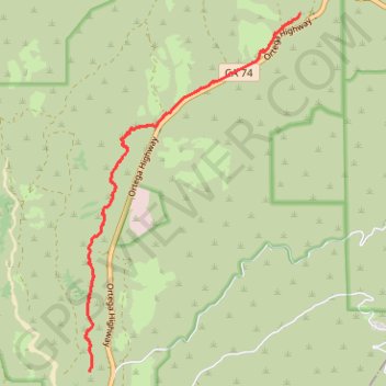
Name: San Juan Hot Springs trail, distance, elevation, map, profile, GPS track
Start: Juaneño Trail, Orange County, California, 92085, United States (33.54052 -117.55221)
End: Juaneño Trail, Orange County, California, 92085, United States (33.54053 -117.55221)
Coordinates: 33.54052 -117.55307 33.58925 -117.51770
Other hiking, mountain biking, running and outdoor activity trails
Click on a trail to view its statistics, map and profile.
