
Angels Landing
From the Zion Canyon floor near the Virgin River, the Angels Landing route follows the West Rim Trail away from The Grotto, climbing quickly above the cottonwoods and canyon walls with widening views toward landmarks such as The Organ, the Great White Throne, and the surrounding sandstone cliffs of Zion Canyon.
The trail then enters the cooler shade of Refrigerator Canyon before tightening into the famous Walter’s Wiggles switchbacks, which lead to Scout Lookout, the broad saddle where hikers look back over the canyon and prepare for the exposed final ridge.
Beyond Scout Lookout, the route follows the narrow, chain-assisted spine of Angels Landing, crossing airy sandstone ledges and steep drop-offs to reach one of Zion National Park’s most dramatic viewpoints, with sweeping perspectives over the Virgin River corridor and the sculpted cliffs of the main canyon.
#Hiking #Canyon #Mountain #River #Forest #Nature #Zion
- Distance: 7.4 Km
- Elevation gain: 766 m
- Maximum elevation: 1,681 m
- Elevation loss: 766 m
- Minimum elevation: 1,307 m
Interactive trail map
Trail profile
- Distance: 7.4 Km
- Elevation gain: 766 m
- Maximum elevation: 1,681 m
- Elevation loss: 766 m
- Minimum elevation: 1,307 m
About this trail
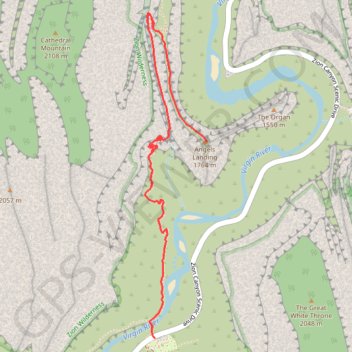
Name: Angels Landing trail, distance, elevation, map, profile, GPS track
Start: Zion Canyon Scenic Drive, Zion Lodge, Washington County, Utah, United States (37.25909 -112.95122)
End: Zion Canyon Scenic Drive, Zion Lodge, Washington County, Utah, United States (37.25909 -112.95122)
Coordinates: 37.25909 -112.95186 37.27599 -112.94785
Other hiking, mountain biking, running and outdoor activity trails
Click on a trail to view its statistics, map and profile.

Scout Lookout
United States > Utah > Washington County > Zion Lodge
From the West Rim Trailhead near the Virgin River, the route leaves the canyon floor and climbs the west side of Zion Canyon, with the river corridor, Zion Canyon Scenic Drive, and the Great White Throne gradually opening across the valley. After the lower switchbacks, the West Rim Trail enters the cooler,…
Distance: 2.8 Km • Elevation gain: 377 m • Maximum elevation: 1,625 m
Emerald Pools, Scout Lookout and Angels Landing
United States > Utah > Washington County > Zion Lodge
Starting at Zion Lodge, the route crosses the Virgin River and enters the Emerald Pools trail system, moving through canyon greenery toward the shaded alcove of Lower Emerald Pool. It then climbs toward Upper Emerald Pool, where sandy tread, stone steps, seasonal water, and high sandstone walls create a…
Distance: 9.7 Km • Elevation gain: 872 m • Maximum elevation: 1,688 m
West Rim Trail to Scout Lookout in Zion National Park
United States > Utah > Washington County > Zion Lodge
Starting with a steady climb after crossing the Virgin River, the West Rim Trail winds through the Refrigerator Canyon before the real challenge begins. Tackling the tight switchbacks of Walter’s Wiggles, you’re rewarded with sweeping views of Zion’s dramatic cliffs, and finally at Scout Lookout, the…
Distance: 6.5 Km • Elevation gain: 554 m • Maximum elevation: 1,656 m

Angels Landing and Emerald Pools (Zion Canyon)
United States > Utah > Washington County > Zion Lodge
Hike from West Rim Trailhead to Angels Landing and Emerald Pools via West Rim Trail, Virgin River, Scout Lookout, Kayenta Trail, Lower Emerald Pool, Middle Emerald Pool and Upper Emerald Pool in the Zion National Park. #Hiking #Canyon #Zion #Nature #River #Rock #Falls
Distance: 11.2 Km • Elevation gain: 1,285 m • Maximum elevation: 1,627 m
Angels Landing via West Rim Trail and Scout Lookout in Zion National Park
United States > Utah > Washington County
Embarking on the Angels Landing via the West Rim Trail is an exhilarating adventure that promises both breathtaking views and a thrilling challenge. After crossing the bridge over the Virgin River, you’ll meander through stunning landscapes, with the coolness of Refrigerator Canyon offering a refreshing…
Distance: 8.0 Km • Elevation gain: 891 m • Maximum elevation: 1,694 m