Thank you for supporting this site ❤️
Make a donation
Make a donation
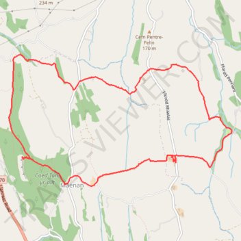
Maenan loop on PRW’s
- Distance: 9.0 Km
- Elevation gain: 252 m
- Maximum elevation: 199 m
- Elevation loss: 251 m
- Minimum elevation: 98 m
- Moving time: 2 h 38 m
- Moving speed: 3.4 Km/h
- Maximum speed: 6.0 Km/h
- Total time: 3 h 20 m
- Global speed: 2.7 Km/h
Interactive trail map
Thank you for supporting this site ❤️
Make a donation
Make a donation
Trail profile
- Distance: 9.0 Km
- Elevation gain: 252 m
- Maximum elevation: 199 m
- Elevation loss: 251 m
- Minimum elevation: 98 m
- Moving time: 2 h 38 m
- Moving speed: 3.4 Km/h
- Maximum speed: 6.0 Km/h
- Total time: 3 h 20 m
- Global speed: 2.7 Km/h
Thank you for supporting this site ❤️
Make a donation
Make a donation
About this trail
Name: Maenan loop on PRW’s trail, distance, elevation, map, profile, GPS track
End: Llanddoged and Maenan, Maenan, Conwy, Wales, LL26 0YD, United Kingdom (53.18202 -3.80544)
Coordinates: 53.18184 -3.81556 53.19607 -3.77530
Thank you for supporting this site ❤️
Make a donation
Make a donation