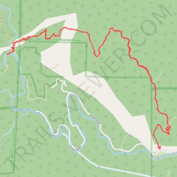
Eldorado Canyon Trail
Interactive trail map
Trail profile
- Distance: 9.7 Km
- Elevation gain: 598 m
- Maximum elevation: 2,166 m
- Elevation loss: 597 m
- Minimum elevation: 1,860 m
- Moving time: 1 h 45 m
- Moving speed: 5.5 Km/h
- Maximum speed: 15.8 Km/h
- Total time: 1 h 53 m
- Global speed: 5.1 Km/h
About this trail
Name: Eldorado Canyon Trail trail, distance, elevation, map, profile, GPS track
Start: Eldorado Springs Drive, Boulder County, Colorado, 80025, United States (39.93096 -105.29395)
End: Eldorado Springs Drive, Boulder County, Colorado, 80025, United States (39.93099 -105.29397)
Coordinates: 39.93096 -105.31593 39.94443 -105.29244
Other hiking, mountain biking, running and outdoor activity trails
Click on a trail to view its statistics, map and profile.
Walker Ranch Loop Trail in Walker Ranch Park
United States > Colorado > Boulder County
The Walker Ranch Loop Trail near Boulder, Colorado, offers hikers a diverse journey through lush forests, open meadows, and along the South Boulder Creek. Along the path, you'll encounter historic remnants of old homesteads, providing a glimpse into the area's past. The trail also features impressive rock…
Distance: 12.2 Km • Elevation gain: 510 m • Maximum elevation: 2,239 m
Eldorado Canyon Trail
United States > Colorado > Boulder County
The Eldorado Canyon Trail in Colorado offers hikers a rewarding journey through diverse terrains, beginning with a steep ascent that provides panoramic views of the canyon's towering rock formations, often dotted with climbers. As the trail progresses, it winds through shaded forests, leading to a ridge that…
Distance: 10.7 Km • Elevation gain: 652 m • Maximum elevation: 2,167 m
New Eldorado Canyon bridge
United States > Colorado > Boulder County > Eldorado Springs
Distance: 3.0 Km • Elevation gain: 289 m • Maximum elevation: 2,094 m