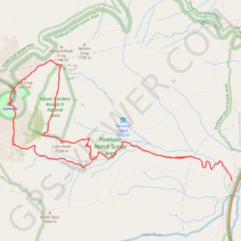
Mount Washington Loop via Tuckerman Ravine Trail, Nelson Crag Trail, Alpine Garden Trail and Lion Head Trail in Pinkham Notch Scenic Area
The Mount Washington Loop offers a diverse and rewarding hiking experience. Hikers are treated to expansive views of Tuckerman Ravine's rugged terrain, Alpine Garden’s delicate alpine meadows, and the jagged peaks of the Presidential Range. While the trail can be challenging with steep ascents and rocky paths, it rewards adventurers with breathtaking panoramas and a sense of accomplishment at the summit of New England's highest peak. #Hiking #Mountain #Forest #Nature #Loop
- Distance: 12.8 Km
- Elevation gain: 1,296 m
- Maximum elevation: 1,911 m
- Elevation loss: 1,123 m
- Minimum elevation: 621 m
Interactive trail map
Trail profile
- Distance: 12.8 Km
- Elevation gain: 1,296 m
- Maximum elevation: 1,911 m
- Elevation loss: 1,123 m
- Minimum elevation: 621 m
About this trail
Name: Mount Washington Loop via Tuckerman Ravine Trail, Nelson Crag Trail, Alpine Garden Trail and Lion Head Trail in Pinkham Notch Scenic Area trail, distance, elevation, map, profile, GPS track
Coordinates: 44.25778 -71.30322 44.27707 -71.25331
Other hiking, mountain biking, running and outdoor activity trails
Click on a trail to view its statistics, map and profile.

Mount Washington Summit Loop via Tuckerman Ravine Trail and Lion Head Trail
United States > New Hampshire > Coos County
Hiking Mount Washington via the Tuckerman Ravine and Lion Head Trails offers a blend of rugged terrain and rewarding views. The route begins at Pinkham Notch Visitor Center and ascends steadily through dense forests, crossing streams and passing waterfalls like Crystal Cascades Falls before reaching the…
Distance: 13.5 Km • Elevation gain: 1,295 m • Maximum elevation: 1,911 m

Presidential Range Traverse
United States > New Hampshire > Coos County > Bowman
Starting near the northern gateway of the Presidential Range, this traverse climbs from the forests of the White Mountain National Forest to the exposed ridgeline of Mount Madison, then continues over the rugged summits of Mount Adams and Mount Jefferson, with wide views across the Great Gulf and the…
Distance: 32.3 Km • Elevation gain: 2,545 m • Maximum elevation: 1,911 m

Mount Washington, Lion Head and Tuckerman Ravine Loop
United States > New Hampshire > Coos County
From Pinkham Notch, the route enters the White Mountain National Forest on the Tuckerman Ravine Trail, climbing through dense northern hardwood and conifer forest beside the Cutler River. An early highlight is Crystal Cascade, where the stream drops through a rocky gorge, before the trail continues steadily…
Distance: 12.6 Km • Elevation gain: 1,325 m • Maximum elevation: 1,911 m

Mount Washington Loop via Nelson Crag Trail, Lion Head and Crystal Cascades Falls
United States > New Hampshire > Coos County
This Mount Washington loop provides a rigorous yet rewarding adventure with diverse landscapes. Starting with a gentle forest walk on Old Jackson Road, the route quickly escalates into rockier terrain, with Nelson Crag offering panoramic views of the Presidential Range. As hikers descend via Lion Head, they…
Distance: 15.5 Km • Elevation gain: 1,356 m • Maximum elevation: 1,911 m

Mount Washington Loop via Boott Spur Trail, Lion Head Trail and Tuckerman Ravine Trail
United States > New Hampshire > Coos County
This loop hike to Mount Washington's summit offers a dramatic blend of terrain, beginning with the serene Crystal Cascade Falls before climbing through rugged, forested paths on the Boott Spur Trail. As hikers ascend, they encounter sweeping views of Huntington Ravine, Tuckerman Ravine, Lion Head and the…
Distance: 14.7 Km • Elevation gain: 1,431 m • Maximum elevation: 1,907 m