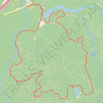
Big River Management Area loop
- Distance: 11.7 Km
- Elevation gain: 111 m
- Maximum elevation: 116 m
- Elevation loss: 111 m
- Minimum elevation: 70 m
- Moving time: 1 h 19 m
- Moving speed: 8.9 Km/h
- Maximum speed: 33.8 Km/h
- Total time: 1 h 27 m
- Global speed: 8.0 Km/h
Interactive trail map
Trail profile
About this trail
Name: Big River Management Area loop trail, distance, elevation, map, profile, GPS track
Coordinates: 41.62512 -71.61718 41.64543 -71.59327
Other hiking, mountain biking, running and outdoor activity trails
Click on a trail to view its statistics, map and profile.
Big River trails
United States > Rhode Island > Kent County > West Greenwich
West Greenwich Trail Running
Distance: 26.5 Km • Elevation gain: 249 m • Maximum elevation: 121 m