Thank you for supporting this site ❤️
Make a donation
Make a donation
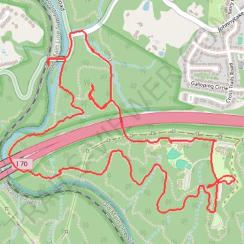
Howard County Trail Running
- Distance: 6.3 Km
- Elevation gain: 140 m
- Maximum elevation: 133 m
- Elevation loss: 140 m
- Minimum elevation: 63 m
- Moving time: 54 m 44 s
- Moving speed: 6.9 Km/h
- Maximum speed: 15.3 Km/h
- Total time: 55 m 44 s
- Global speed: 6.8 Km/h
Interactive trail map
Thank you for supporting this site ❤️
Make a donation
Make a donation
Trail profile
- Distance: 6.3 Km
- Elevation gain: 140 m
- Maximum elevation: 133 m
- Elevation loss: 140 m
- Minimum elevation: 63 m
- Moving time: 54 m 44 s
- Moving speed: 6.9 Km/h
- Maximum speed: 15.3 Km/h
- Total time: 55 m 44 s
- Global speed: 6.8 Km/h
Thank you for supporting this site ❤️
Make a donation
Make a donation
About this trail
Name: Howard County Trail Running trail, distance, elevation, map, profile, GPS track
Coordinates: 39.30228 -76.79614 39.31177 -76.78091
Thank you for supporting this site ❤️
Make a donation
Make a donation