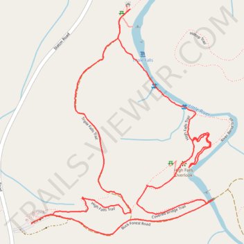
Triple Falls and High Falls Trails Loop in Dupont State Recreational Forest
The Triple Falls and High Falls Trails Loop in Dupont State Recreational Forest offers hikers captivating views of two prominent waterfalls. Along the trail, you'll first encounter Triple Falls, a stunning three-tiered cascade, followed by High Falls, a majestic waterfall that plunges over a wide rock face. The path winds through lush hardwood forests, providing scenic vistas and opportunities to explore the base of these impressive falls. #Hiking #Loop #Waterfall #River #Forest #Nature
- Distance: 5.1 Km
- Elevation gain: 105 m
- Maximum elevation: 786 m
- Elevation loss: 105 m
- Minimum elevation: 723 m
- Moving time: 1 h 6 m
- Moving speed: 4.6 Km/h
- Maximum speed: 8.7 Km/h
- Total time: 1 h 14 m
- Global speed: 4.1 Km/h
Interactive trail map
Trail profile
- Distance: 5.1 Km
- Elevation gain: 105 m
- Maximum elevation: 786 m
- Elevation loss: 105 m
- Minimum elevation: 723 m
- Moving time: 1 h 6 m
- Moving speed: 4.6 Km/h
- Maximum speed: 8.7 Km/h
- Total time: 1 h 14 m
- Global speed: 4.1 Km/h
About this trail
Name: Triple Falls and High Falls Trails Loop in Dupont State Recreational Forest trail, distance, elevation, map, profile, GPS track
Coordinates: 35.19084 -82.62258 35.20028 -82.61328
Other hiking, mountain biking, running and outdoor activity trails
Click on a trail to view its statistics, map and profile.
Triple Falls Trail and High Falls Trail in Dupont State Recreational Forest
United States > North Carolina > Transylvania County
The Triple Falls and High Falls Trails in Dupont State Recreational Forest offer hikers a scenic journey through lush forests, leading to the impressive Triple Falls—a three-tiered cascade featured in films like "The Hunger Games"—and culminating at the majestic High Falls, a 150-foot waterfall that slides…
Distance: 3.7 Km • Elevation gain: 109 m • Maximum elevation: 762 m