Make a donation
Trail Canyon Falls in Angeles National Forest
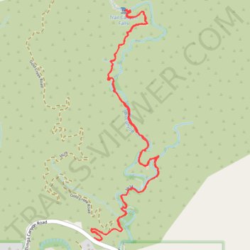
The hike to Trail Canyon Falls in the Angeles National Forest offers a moderately challenging journey through diverse landscapes. As you traverse the trail, you'll encounter a babbling creek, verdant forests, rugged canyon walls, and enjoy views of the San Gabriel Mountains. The trail culminates at the picturesque 30-foot Trail Canyon Falls, where water cascades down a rocky face into a serene pool below. #Hiking #Waterfall #Canyon #Mountain #Forest #Nature
- Distance: 7.6 Km
- Elevation gain: 366 m
- Maximum elevation: 757 m
- Elevation loss: 367 m
- Minimum elevation: 539 m
- Moving time: 2 h 15 m
- Moving speed: 3.4 Km/h
- Maximum speed: 7.1 Km/h
- Total time: 2 h 36 m
- Global speed: 2.9 Km/h
Interactive trail map
Make a donation
Trail profile
- Distance: 7.6 Km
- Elevation gain: 366 m
- Maximum elevation: 757 m
- Elevation loss: 367 m
- Minimum elevation: 539 m
- Moving time: 2 h 15 m
- Moving speed: 3.4 Km/h
- Maximum speed: 7.1 Km/h
- Total time: 2 h 36 m
- Global speed: 2.9 Km/h
Make a donation
About this trail
Name: Trail Canyon Falls in Angeles National Forest trail, distance, elevation, map, profile, GPS track
Start: North Trail Canyon Road, Los Angeles County, California, United States (34.30376 -118.25797)
End: Big Tujunga Canyon Road, Los Angeles County, California, United States (34.30379 -118.25813)
Coordinates: 34.30359 -118.25840 34.32048 -118.25239
Make a donation
Other hiking, mountain biking, running and outdoor activity trails
Click on a trail to view its statistics, map and profile.
Trail Canyon Trail to Trail Canyon Falls
United States > California > Los Angeles County
Distance: 3.1 Km • Elevation gain: 266 m • Maximum elevation: 755 m