Make a donation
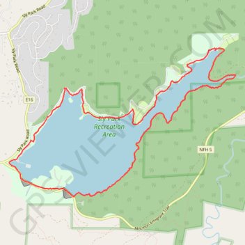
Jenkinson Lake Loop
Starting from the Sly Park Road access, this counter-clockwise route begins along the south shore of Jenkinson Lake, passing the Sly Park Saddle Dam and Sly Park Dam before joining the named Jenkinson Lake Loop.
The trail then follows the quieter wooded side of the lake, weaving around small coves and shoreline bends before reaching the more enclosed upper end near Park Creek Bridge and the waterfall spur.
The return follows the north shore through a more varied mix of lakeside trail, forest edges, peninsulas, road-adjacent passages, and boat-access areas, completing a scenic multi-use circuit around Jenkinson Lake for hiking, running, and mountain biking.
#Hiking #Running #MTB #Loop #Lake #Forest #Nature
- Distance: 13.1 Km
- Elevation gain: 292 m
- Maximum elevation: 1,104 m
- Elevation loss: 292 m
- Minimum elevation: 1,055 m
- Moving time: 1 h 32 m
- Moving speed: 8.5 Km/h
- Maximum speed: 38.4 Km/h
- Total time: 2 h 53 s
- Global speed: 6.5 Km/h
Interactive trail map
Make a donation
Trail profile
- Distance: 13.1 Km
- Elevation gain: 292 m
- Maximum elevation: 1,104 m
- Elevation loss: 292 m
- Minimum elevation: 1,055 m
- Moving time: 1 h 32 m
- Moving speed: 8.5 Km/h
- Maximum speed: 38.4 Km/h
- Total time: 2 h 53 s
- Global speed: 6.5 Km/h
Make a donation
About this trail
Name: Jenkinson Lake Loop trail, distance, elevation, map, profile, GPS track
Start: Mormon Emigrant Trail, El Dorado County, California, 95726, United States (38.71737 -120.57097)
End: Mormon Emigrant Trail, El Dorado County, California, 95726, United States (38.71736 -120.57096)
Coordinates: 38.71459 -120.57326 38.73732 -120.52871
Make a donation