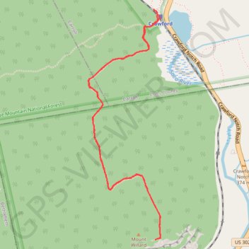
Mount Willard Trail in White Mountain National Forest
The Mount Willard Trail provides an accessible yet rewarding hike with exceptional views. As you ascend, you pass through a fragrant forest, encountering small waterfalls and serene pools before reaching a rocky, steeper section that leads to the summit. At the top, the panoramic vista of Crawford Notch and the Saco River Valley is spectacular, offering a quiet spot to relax and soak in the natural beauty of the surrounding White Mountains. #Hiking #Mountain #Overlook #Forest #Nature
- Distance: 5.1 Km
- Elevation gain: 301 m
- Maximum elevation: 849 m
- Elevation loss: 302 m
- Minimum elevation: 575 m
- Moving time: 1 h 21 m
- Moving speed: 3.8 Km/h
- Maximum speed: 10.0 Km/h
- Total time: 1 h 37 m
- Global speed: 3.1 Km/h
Interactive trail map
Trail profile
- Distance: 5.1 Km
- Elevation gain: 301 m
- Maximum elevation: 849 m
- Elevation loss: 302 m
- Minimum elevation: 575 m
- Moving time: 1 h 21 m
- Moving speed: 3.8 Km/h
- Maximum speed: 10.0 Km/h
- Total time: 1 h 37 m
- Global speed: 3.1 Km/h
About this trail
Name: Mount Willard Trail in White Mountain National Forest trail, distance, elevation, map, profile, GPS track
Start: A-Z Trailhead, Avalon Trail, Carroll, Coös County, New Hampshire, United States (44.21836 -71.41189)
End: Avalon Trail, Carroll, Coös County, New Hampshire, United States (44.21794 -71.41147)
Coordinates: 44.20363 -71.41772 44.21836 -71.41129
Other hiking, mountain biking, running and outdoor activity trails
Click on a trail to view its statistics, map and profile.
Mount Field, Mount Willey, Mount Avalon and Mount Tom Loop
United States > New Hampshire > Coos County > Carroll
Loop hike from Sako Lake via Avalon Trail, Mount Avalon, Mount Field, Willey Range Trail, Mount Willey, Mount Tom Spur, Mount Tom and A-Z Trail in the White Mountain National Forest. #Hiking #Loop #Mountain #Nature #Forest #Lake
Distance: 15.2 Km • Elevation gain: 1,021 m • Maximum elevation: 1,299 m