
Marty Bender Nature Area Loop Trail
Starting at the junction of East Brad Way and South Holmes Road, the Marty Bender Nature Area Loop Trail heads west into The Land Institute’s public prairie, passing open grassland, working hay fields, and nearby research plots.
The loop then turns through remnant prairie and a wooded corridor along the Smoky Hill River, where plant life, wildlife habitat, shaded edges, and river overlooks shape the middle section of the hike.
It returns across the rolling Central Kansas prairie toward the trailhead, with art features, picnic spots, broad views over the Salina area, and the quiet Great Plains setting completing the route.
#Hiking #Loop #Nature #River #Country #Forest
- Distance: 4.6 Km
- Elevation gain: 56 m
- Maximum elevation: 411 m
- Elevation loss: 56 m
- Minimum elevation: 377 m
- Moving time: 1 h 9 m
- Moving speed: 4.0 Km/h
- Maximum speed: 5.5 Km/h
- Total time: 1 h 18 m
- Global speed: 3.5 Km/h
Interactive trail map
Trail profile
- Distance: 4.6 Km
- Elevation gain: 56 m
- Maximum elevation: 411 m
- Elevation loss: 56 m
- Minimum elevation: 377 m
- Moving time: 1 h 9 m
- Moving speed: 4.0 Km/h
- Maximum speed: 5.5 Km/h
- Total time: 1 h 18 m
- Global speed: 3.5 Km/h
About this trail
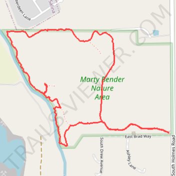
Name: Marty Bender Nature Area Loop Trail trail, distance, elevation, map, profile, GPS track
Start: Marty Bender Nature Area trail, Saline County, Kansas, United States (38.78391 -97.55814)
End: East Brad Way, Saline County, Kansas, 67401, United States (38.78384 -97.55793)
Coordinates: 38.78293 -97.57207 38.79087 -97.55788