Hawksbill Mountain Trail in Linville Gorge Wilderness
The Hawksbill Mountain Trail offers hikers an accessible but rewarding adventure in the heart of the Linville Gorge Wilderness. As you climb through rhododendron-filled forests, you’ll encounter rock outcroppings that reward you with breathtaking panoramic views of the gorge below, including vistas of Table Rock and Grandfather Mountain. This relatively short hike is a great option for those seeking the grandeur of the Linville Gorge without committing to longer, more strenuous routes. #Hiking #Mountain #Forest #Overlook #Nature
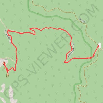
- Distance: 3.4 Km
- Elevation gain: 207 m
- Maximum elevation: 1,202 m
- Elevation loss: 208 m
- Minimum elevation: 1,007 m
- Moving time: 51 m 35 s
- Moving speed: 4.0 Km/h
- Maximum speed: 8.6 Km/h
- Total time: 1 h 19 m
- Global speed: 2.6 Km/h
Interactive trail map
Trail profile
- Distance: 3.4 Km
- Elevation gain: 207 m
- Maximum elevation: 1,202 m
- Elevation loss: 208 m
- Minimum elevation: 1,007 m
- Moving time: 51 m 35 s
- Moving speed: 4.0 Km/h
- Maximum speed: 8.6 Km/h
- Total time: 1 h 19 m
- Global speed: 2.6 Km/h
About this trail
Name: Hawksbill Mountain Trail in Linville Gorge Wilderness trail, distance, elevation, map, profile, GPS track
Start: Lettered Rock, Burke County, North Carolina, United States (35.91464 -81.87832)
End: Lettered Rock, Burke County, North Carolina, United States (35.91470 -81.87838)
Coordinates: 35.91268 -81.88624 35.91590 -81.87832
Other hiking, mountain biking, running and outdoor activity trails
Click on a trail to view its statistics, map and profile.
Hawksbill Trail in Linville Gorge Wilderness
United States > North Carolina > Burke County
The Hawksbill Trail in Linville Gorge offers a rewarding hiking experience that begins with a gradual climb through a forested path lined with rhododendron and hardwood trees. As you ascend, the trail becomes steeper and rockier, with the final stretch requiring a bit of a scramble before reaching the summit.…
Distance: 3.6 Km • Elevation gain: 212 m • Maximum elevation: 1,202 m